RECEIVING DATA FROM WEATHER SATELLITES
The Automatic Picture Transmission (APT) system is a type of analog image transmission system that was designed for use on meteorological satellites. It was established in the 1960s and has given image data to relatively low-cost user stations in most nations worldwide for the past five decades. A user station anywhere in the world can receive local data from each satellite as it passes nearly overhead at least twice daily. Currently, I receive data from the NOAA 15, 18, and 19 which are the only ones still transmitting APT. I also recieve data from the Russian weather satellite Meteor M N2-3 which transmits digitally (LRPT) and has a higher bandwidth and more channels compared to APT.
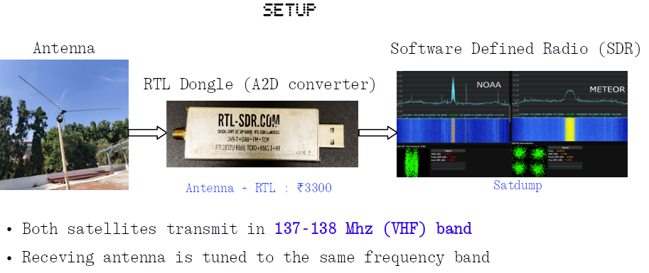
Using a suitable antenna, RTL-SDR dongle and SDR software (such as GQRX or SatDump), we can acquire the NOAA APT and Meteor QPSK signals. The incoming signal which is visible on the FFT spectrum and the waterfall is recorded as a WAV audio (FM demodulation) / baseband (for Meteor) file for further processing. The WAV file can be directly proccessed using the noaa-apt tool. Alternatively, SatDump can be used to recieve and procces these signals in one go. This proccess can also be automated (my current setup) using the RaspiNOAA V2 on a Raspberry Pi.
After demodulation, we get the raw images from two transmission channels (generally red and near/far infrared) captured by the AVHRR sensors onborad NOAA satellites. Further enhancements can be made to these two channels to generate False Color Composites (FCC)/Multispectral imagery. However, Meteor transmissions have 3 channels (generally 2 visible, 1 infrared) and so the generated images are true color composites.
An excellent guide is available here if you want to try this out for yourself : Jacopo's LairRECENT IMAGES
The weather satellite images are automatically updated once every 3 days .